
Where the Boats Were Built: A Walk Through Ithaca's West End
Stand at the end of West Seneca Street today and it's easy to miss what was once there. Prior to the 1960s the street extended as far as Floral Avenue. Now, the street dead-ends at a flood control channel — a project of the late 1960s — and beyond it, the Inlet moves quietly past. But in the decades after the Civil War, this was one of the most industrious stretches in all of Ithaca. The sound of saws and hammers filled the air. Canal boats took shape in dry dock. And at its peak, ten boat yards employed 150 men in steady work, sending vessels out to the Erie Canal and beyond.
Photographs and maps from The History Center’s archives can help to make sense of the varied and disjointed layers of historical built environment that currently coexist in that area, especially those that are beyond living memory. An 1872 map of the Village of Ithaca in The History Center’s collections shows the west end of Seneca Street lined by several old boat yards flanking the Inlet as it wound its way east toward Westport Street (now Taughannock Boulevard).(1) Joseph C. Burrit, a prolific photographer of Ithaca and beyond, captured this precise area from above Spencer Road (which is now Floral Avenue) in the 1860s. The image shows boat yards in the foreground with long wooden canal boats lining the dark inlet banks.(2)
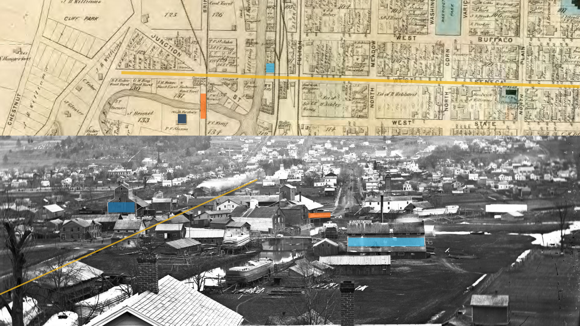
Photograph by Burrit compared to the 1972 A.G. Bardin map, with landmarks matched via color. West Seneca St is represented by a yellow line.
The first boat yard on the left, in the photo, was run by Benjamin F. Taber. His boatyard turned out more than 250 craft over its lifetime — horse-drawn barges, lake steamboats, even luxury yachts. Another boat builder, Gilbert T. Garrett, whose boat yard was to the left of the old Sign Works building at the corner of Seneca and Brindley Streets, made about one hundred boats. His son Charles later recalled that Garrett used a fine white oak that took a day to be delivered from Reynoldsville. The lumber was hand sawed and steamed to make it bendable. (3)
By 1874, the Ithaca Daily Journal declared boatbuilding "the principal manufacturing industry of Ithaca." (4) But the railroads were coming — and with them, a long, slow squeeze on the water routes. The yards went quiet. The neighborhood shifted. The flood channel erased the last of the street grid. Layers accumulated: trains, then trolleys, then the runway of an airplane factory, then the tangle of roads locals called the Octopus.
All of it is still there, if you know how to look.
On Thursday, March 19th at 5:30 pm, The History Center in Tompkins County invites you to do exactly that. Our West End Tour, offered in collaboration with Swamp City Community Cycles, is a 90-minute guided walk through the city's most storied — and overlooked — neighborhood. Starting at 124 Brindley Street (the former site of Gilbert Garrett's boat yard), the route traces Ithaca's transformation from a canal port to the birthplace of Tommy planes, home of the third electric streetcar system in New York State, and site of one of the most notorious intersections in local memory.
This one-mile walk is designed for anyone who wants a deeper connection to the city they live in. Wear comfortable shoes and come ready to see Ithaca differently.
Rain date: March 26th. Registrants will be notified by noon on the 19th if the event is rescheduled.
A. G. Bardin, Map of the Corporation of Ithaca,Tompkins County, New York, Philadelphia: T.C. Van Arsdale & Co., 1872.
Joseph Burritt Collection N6.139.
"B.F. Taber Called To His Reward: Aged and Respected Resident Died This Afternoon," Ithaca Daily Journal, February 19, 1909, 3; Interview of Charles C. Garrett, Temporary Emergency Relief Administration, April 1935, The History Center in Tompkins County.
“Revival of Business,” Ithaca Daily Journal, March 28, 1874, 4.